
Able Humber Port
Able Humber Port, Rosper Road, South Killingholme, Immingham DN40 3DZ
what3words address: ///diver.forgiving.tones
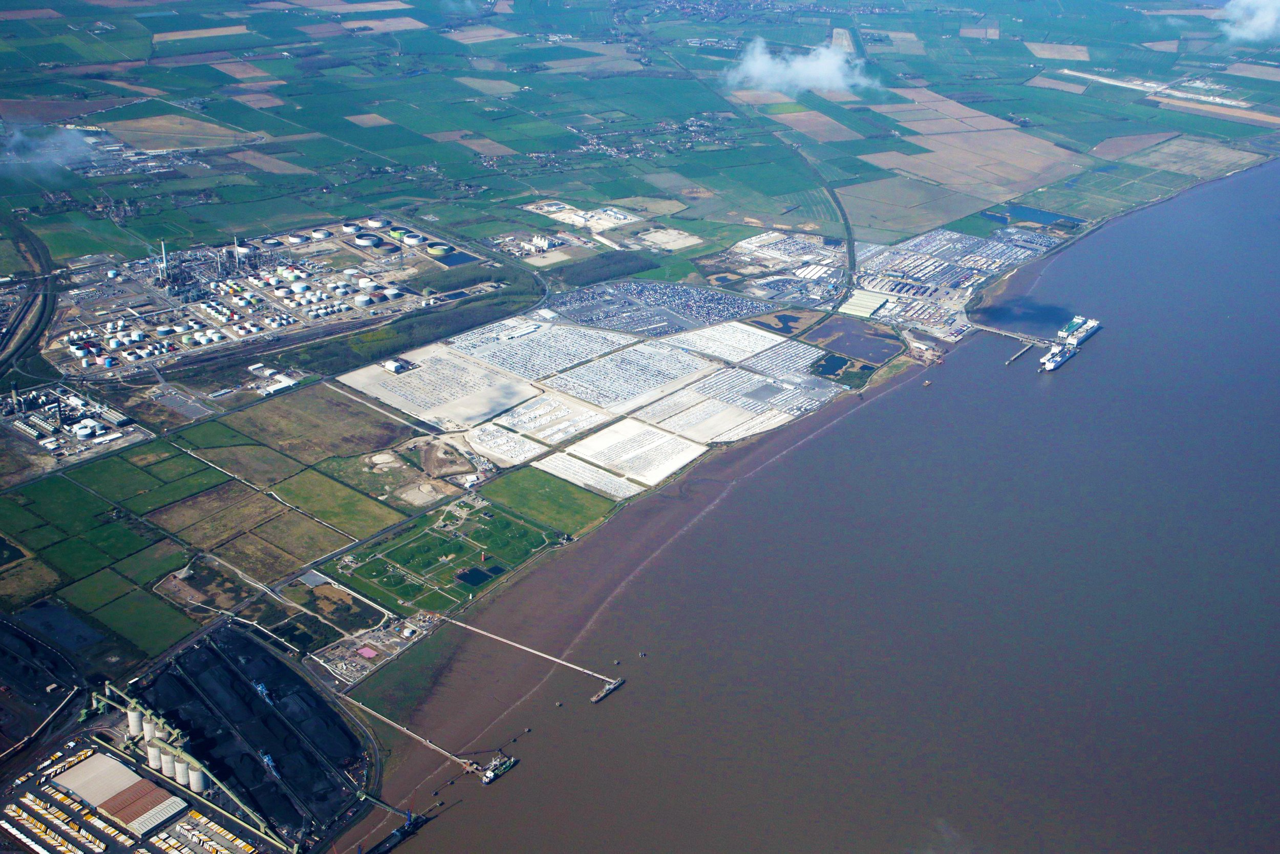
Able Humber Port (AHP) is situated on the South Bank of the Humber Estuary, East Coast of the UK. The Humber has been described as the Energy Estuary and in recent years it has been the UK’s fastest growing port and logistics centre.
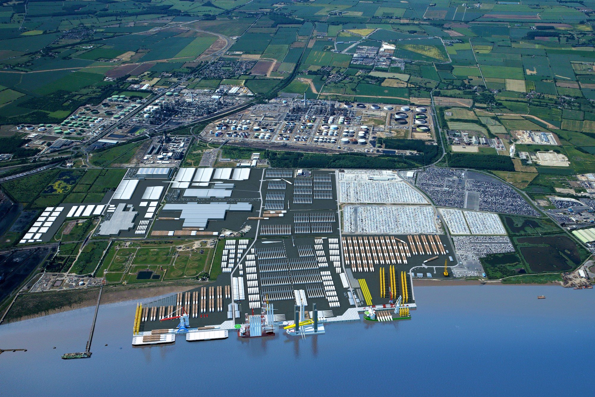
AHP, potentially Europe’s largest new port development providing an exciting proposal for the burgeoning marine renewable energy sector; this includes Able Energy Park (AEP) providing an additional c. 1,000 acres of hinterland development to support a wide variety of port centric logistics functions.
The UK Government has identified AHP as a strategic location in the National Renewable Infrastructure Plan and has confirmed AHP as a member of the Humber Freeport Zone.
Click the image below to visit the Humber Freeport Website:

Able Humber Port Brochure
To date £50m has been invested in preparing AHP for the speedy construction of industrial facilities for its tenants.
AHP has the scale of land, the size and design of quays, that allow for significant expansion in terms of both plant and overall capacity.
The site is flat with a UDL of 10t/m2 and a patch load of 50t/m2 with no risk of environmental contamination.
In the heart of an industrial area and with no residential neighbours, AHP is suitable for operations to work 24hours per day; 7 days per week, as required.
We understand that tenants will require individual, bespoke capital equipment. However, to reduce up front capital expenditure AHP will provide multi-user services that are available to hire such as large cranes, reach/lift trucks, dock cranes and SPMTs.
AHP is adjacent to the Able Energy Park (AEP) – a greenfield site with full planning permission granted for the creation of extensive warehousing (1,700,000m2 ), external storage and transportation depots. The development of AEP will complement AHP’s tenants activities, potentially enabling a just in time approach minimising inventories, sustaining and maximising efficiencies and workflow concepts.
Enterprise Zone status includes Special Planning Zone (SPZ) benefits to expedite the detailed planning process for potential clients.
AHP will include a business park with new offices that can accommodate a range of supporting organisations undertaking tasks such as environmental and geotechnical assessments, legal financial and insurance services, planning, engineering and design.
Lighting – 45m high lighting columns across the site with 30m lighting columns within the business park and supplier park areas.
Security – 24 hour security with gate houses on all designated entrances. The port will have full industry security accreditations.
The development land has been designed to the appropriate flood defence levels agreed and established by the UK Environment Agency. This is on the basis of a flood risk assessment and will accommodate the 1 in 200 year tidal event, which has an annual occurrence probability of 0.5%.
| Quay Feature | Information |
|---|---|
| Total Quay Length | 1,288m |
| Quay Surface | Concrete |
| Quay Capacity | 20t/m² to 100t/ m² patch load |
| Max. Dredge Depth | -17.0mCD |
| Max. Water Depth (MHWS) | 24.3m |
| Berthing Pocket | 80m wide |
| Bollards | 150Te, 30m apart |
| Quay Yard Areas | 91ha (224 Acres) |
| Interruptions | The area has no history of operations being interrupted by ice or sand |
| Vessels | Quays designed to allow vessels to jack-up alongside and berth side by side |
Working closely with local and national stakeholders there is a shared ambition to ensure that AHP has full Freeport status..
The Humber Freeport bid was successful (Chancellors Budget Speech 3rd March 2021) and AHP will offer the benefits of being both a Freeport Customs Site and a Freeport Tax Site.
In addition to the deferred customs and duty charges on products the Tax Site benefits will include:
STAMP DUTY LAND TAX (SDLT)
100% relief on leases executed before 31 March 2026 SDLT is s a function of the net present value of rent (to the end of the term [excluding breaks]). It would normally be paid at the rate of
1% (up to £5m) and thereafter at 2%.
ENHANCED STRUCTURES AND BUILDINGS ALLOWANCE (SBA)
This accelerated relief is intended to allow firms to reduce their taxable profits by 10% of the cost of investment every year for ten years (compared with the standard 3% p.a. over 33 and a
third years. This relief would be claimable against qualifying expenditure.
ENHANCED CAPITAL ALLOWANCES (ECA)
Will provide enhanced tax relief for companies investing in qualifying new plant and machinery assets. This accelerated relief is intended to allow firms to reduce their taxable profits by the full cost of the qualifying investment in the same tax period the cost was incurred. This relief would be claimable against qualifying expenditure.
EMPLOYER NATIONAL INSURANCE CONTRIBUTIONS (NICS) RATE RELIEF
Employers operating in a Freeport tax site would pay 0% employer NICs on the salaries of any new employee working in the Freeport tax site. This 0% rate would be applicable for up to three years per employee on earnings up to a £25,000 per annum threshold. Normally, employers pay National Insurance (NI) on all earnings over £732 per month (£8,784 pa). Under the proposed regime employers only pay NI on all earnings over £2,083 per month (£25,000 pa) and save 13.8% on the difference, ie £2,238 (13.8% of £16,216).
BUSINESS RATES RELIEF
100% relief on the first five years.


IN ADDITION AHP WILL:
Dramatically reduce the industry’s expenditure on delivery and installation vessels
Introduce a new, fixed, transparent charging model for operating the quays. A fixed price charging model provides stability and a huge cost saving when compared to other port costs
Allow lower delivered costs for components by dramatically reducing the number of supply chain interventions (lifts and moves), reducing the components ‘journey’ and overall industry carbon footprint’
Please view or download the files below for the DCO Extension at Able Humber Port:
Able Humber Ports (AHP) is situated on the South bank of the Humber Estuary, East Coast of the UK, which in recent years has been the UK’s fastest growing port and logistics centre.
The ABLE Group is a well resourced, privately owned company with a strong track record in delivery. It has the ability to make quick decisions and is fully prepared to speculate to meet the demanding requirements of it’s customers.
The full Able Humber Ports project comprises three developments: the Able Humber Port itself (AHP); the Able Energy Park (AEP) and the Able Humber Ports Business Park (AHPBP) providing a developable land area of over 560 ha (1,383 acres). AHP forms part of the UK’s largest Enterprise Zone.
To date over 93 ha (230 acres) is occupied by vehicle distribution activities and a further 98 ha (273 acres) is currently available and can also accommodate peak seasonal requirements. The site has successfully accommodated this type of activity since 1999.
The central North Sea coastal location provides ease of access by sea – the Humber is over 3km wide providing straightforward entry/egress and manoeuvrability for most types of shipping. The central United Kingdom location provides HGV access to UK distribution outlets by road with dual carriageway access to major motorways (M18 35 miles [56km]; A1M 47 miles [75km]) and the dualling of the A160/A180 has been completed.
Rail Access
AHP has an existing rail connection that is available for the import and export of vehicles.
Ro-Ro Availability
AHP is adjacent to the CLdN Ro-Ro Terminal (the former Humber Sea Terminal). It is also within 1.85 miles [3km] of the facilities at Immingham Port, including DFDS. ABLE also has plans to develop its own Ro-Ro facility.
Land
AHP is a large green field development with no land contamination issues or associated contingent liabilities. AHP also prohibits the shipping and storage of potential bulk contaminants e.g. coal and biomass.
Flood Protection
The tarmac surfaces at AHP were not impacted by the exceptional tidal surge event in December 2013, in sharp contrast to neighbouring facilities. Furthermore on-going investment is increasing the level of protection to meet the Environment Agency’s exacting target to combat rises in sea level for the next 60 years. AEP is over 1m above the highest level of forecasted sea level increase.
Miscellaneous and Ambient Conditions
Since acquisition the location has not experienced any impact from air contamination. Flooding, hail, bird activity and freezing conditions have only rarely been encountered.
For further information please call our Development Team on (0)1642 806080
The Humber Estuary is the largest coastal plain estuary on the east coast of Britain. The estuary is comprised of two shipping channels: The Sunk Channel and the Grimsby Roads Channel.
Points of Contact:
Please visit www.humber.com to view the ABP Humber Estuary Services web site which includes shipping tariffs for using the river.
Harbour Master
For general enquiries including the issuing of Notices to Mariners contact: hesharbourmaster@abports.co.uk
Pilotage Department
All pilotage enquiries including vacancies and enquiries relating to pilot exemption Certificates contact: hespilotage@abports.co.uk
Vessel Traffic Services (VTS)
For operational enquiries including serious marine incidents, use of traffic separation scheme, reporting to VTS, defective navigation lights and marks out of position, bunkering, VHF frequencies and anchorages contact: hesvts@abports.co.uk
Hydrographic Department
For chart enquiries, surveying the estuary, tidal enquiries, buoyage contact: heshydrography@abports.co.uk
Svitzer Humber Ltd
SMS Towage
Humberside Airport
| Characteristics | Information |
|---|---|
| Air Draft Restrictions | None |
| Sunk Channel Width | 180m -9.50mCD |
| Grimsby Roads Channel Width | 660m -6.00mCD |
| Mean High Water Springs (MHWS) | 7.30mCD |
| Mean Low Water Springs (MLWS) | 0.90mCD |
| Mean High Water Neap (MHWN) | 5.80mCD |
| Mean Low Water Neap (MLWN) | 2.60mCD |
| Highest Astronomical Tide (HAT) | 7.99mCD |
| Lowest Astronomical Tide (LAT) | 0.16mCD |
| Max. Depth of Water (MHWS) at Quayside | 24.80m |
| Quayside Height | 10.00mCD |